Detecting encroaching
Encroachment
What is encroachment and how our aerial mapping service helps to resolve it.
Encroaching on someone's land refers to the act of trespassing or unlawfully intruding onto another person's property without their permission or legal right to do so. This can take various forms, including building structures, cultivating crops, or conducting activities on land that legally belongs to someone else.
Encroachment can occur due to misunderstandings, disputes over property boundaries, or intentional actions by a neighbouring landowner. It often leads to conflicts and legal disputes between the parties involved.
Resolving encroachment issues typically involves legal procedures, such as obtaining land surveys, negotiating with the encroaching party, or, in more serious cases, pursuing legal action through courts. It's crucial to establish property boundaries and rights to prevent or address encroachment problems.
In summary, encroachment is a contentious issue involving the unauthorized use or occupation of another person's land, and it requires careful legal handling to ensure fair resolution for all parties involved.
The drone mapping technology is a valuable tool for landowners as it aids in detecting encroachments.
In this article, we will share our experience in detecting encroachments and illegal logging on the island of Taveuni in Fiji using high accuracy survey grade aerial mapping using RPA (Remotely Piloted Aircraft) also commonly known as drone.
We were approached by a landowner on Taveuni Island who expressed concerns about his 90-acre land being encroached upon by his neighbour. Suspecting some valuable timber was cut down and some areas of the land had been farmed without his consent.
Detecting and documenting encroachments typically requires hiring a licensed land surveyor, which often comes with significant expenses, especially for remote and challenging-to-reach areas of tropical terrain.
While a licensed land surveyor will be necessary indeed if you intend to take further legal action, opting for a significantly less costly approach such as aerial mapping and surveying with a drone can assist a landowner in making a well-informed decision about whether they need to engage a licensed surveyor.
Armed with well-documented evidence, they could address the matter directly with the trespasser, saving a significant amount of budget and time.
So, what would we need to detect, assess, and document encroachments over a parcel of land?
Step 1
The correct and up to date geographically referenced boundaries of the land parcel
In Fiji there are two main ways of getting them
- Plan A - request them from the government authority i.e. Lands Department (be prepared for Fiji Time. A lot of it) Most likely it will get you nowhere, but worth trying. Especially if you have good personal connection in the GIS department or occasionally handshake the Minister of Lands and Mineral Resources youself then Plan A is definitely for you.
- Plan B - for commoners. Digitize the boundaries from VanuaGIS Fiji website. Unfortunately, the Vanua GIS, despite of having ArcGIS engine under the hood, has quite limited usefulness. You can see the boundaries of the land, but you can do very little with it and you can't simply have them.
Anyway. If you are a land owner in Fiji and need your land boundaries in digital geo-referenced format for personal use. For example you can plan your subdivisions yourself or give it to someone overseas. Contact us, we will be able to help with it in most cases.
So, you've got the boundaries of your land in one of the popular basic geographical vector formats. KML or GeoJSON.
What next?
Step 2
Upload your land boundaries vector in Map Hub
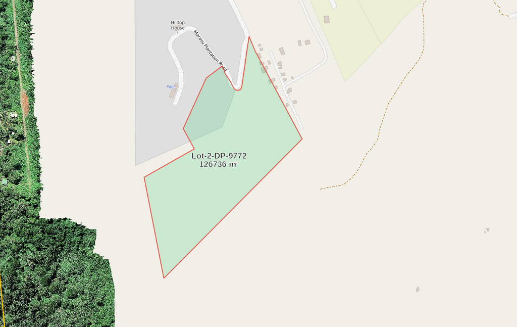
Uploading your land boundaries in Map Hub will place them on the world map where you can later add an aerial map overlay.
Having your boundaries in Map Hub gives you simple and easy way no only visually assess your land, but also understand what is actually happening withing your boundaries and what outside. Using the vector tools from the tool bar on the right you can measure any area, put your own marks and notes, save your map in PDF file or share it online privately or open for public.
Step 3
Aerial mapping
For aerial mapping, you can hire a drone operator equipped with survey-grade GNSS equipment capable of producing aerial maps with centimetre-level accuracy. We offer an affordable aerial drone mapping service in Fiji for landowners of any size.
Northern Frontiers SAS is our air operation wing. CAAF licensed, authorised and equipped for commercial UAV operation in Fiji. Visit their website for more details, rates and quotation.
During aerial mapping, the drone scans the land, producing highly accurate and detailed photo maps. And it's not just photographic images. From the data collected we can also build Digital Surface and Terrain models, 3D terrain reconstruction, and other valuable digital products, that provide a wealth of useful technical and engineering information about the land.
For high accuracy aerial mapping the drone should have GNSS receiver to collect data for further RTK or PPK processing that if done well, comes with centimetre level accuracy of the map's raster that is acceptable for detecting and precisely locating such matters as encroachment, illegal logging, rubish dumps and other abnormalities withing your land boundaries.
Step 4
Visualising and detecting encroachment using Map Hub
Why we love Map Hub is because it is simple. A user without any GIS background can use it.
- Open Map Hub
- Sign in with your Google account
- Upload your land aerial map raster directly from your PC or feeding it the link to one of cloud storage facilities like Google Drive or Mega
- Upload boundaries vector polygons in GeoJSON or KML format
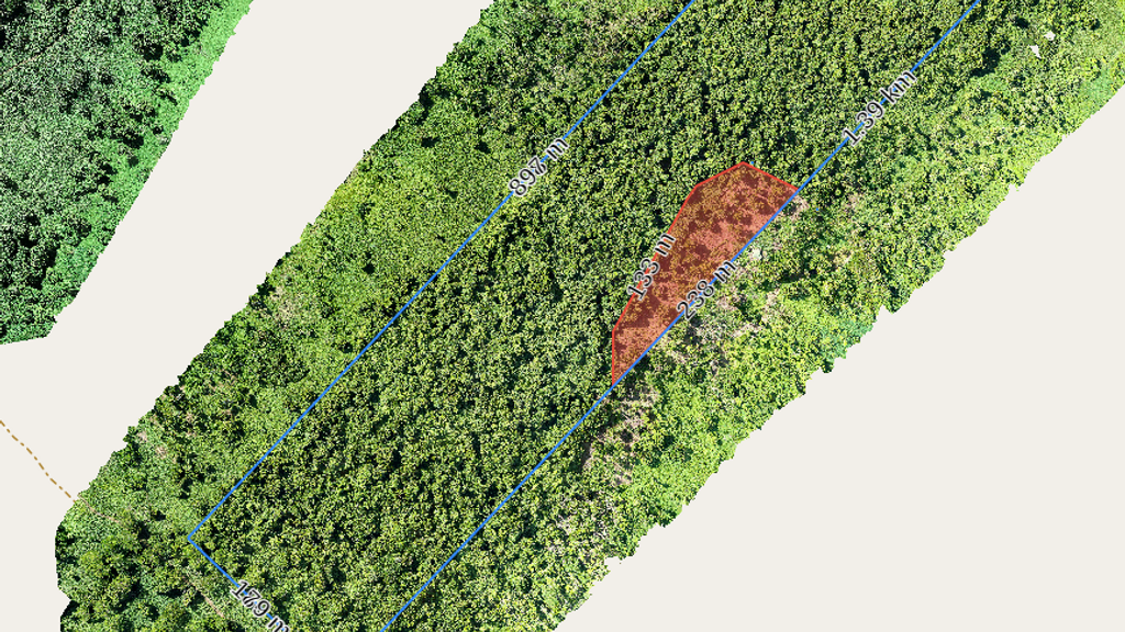
Once you get there your aerial photo map raster with boundaries overlay, you can visually detect abnormalities by zooming the raster and locate them wether withing the boundaries or outside of them.
In Map Hub you can also save your mapping and all the vector element in PDF file for printing and sharing.
Map Hub also allow you to share your aerial maps either publicly or privately with other parties and stakeholders.
The sample of real map with boundaries overlay and encroachment zone marked in red